
Ferndale, Washington
Ferndale, Washington | |
|---|---|
 Downtown Ferndale | |
 Seal | |
 Location of Ferndale, Washington | |
| Coordinates: 48°50′47″N 122°35′28″W / 48.84639°N 122.59111°W | |
| Country | United States |
| State | Washington |
| County | Whatcom |
| Incorporated | March 19, 1907 |
| Government | |
| • Type | Mayor–council |
| • Mayor | Greg Hansen |
| • City Council | Herb Porter Ali Hawkinson Erin Gunter McKenna Pinto-Gonzalez Ryan O'Larey Robert Pinkley Jon Mutchler |
| Area | |
| • City | 7.14 sq mi (18.49 km2) |
| • Land | 7.03 sq mi (18.20 km2) |
| • Water | 0.11 sq mi (0.27 km2) |
| Elevation | 36 ft (11 m) |
| Population | |
| • City | 15,048 |
| • Estimate (2023)[4] | 15,992 |
| • Density | 2,276/sq mi (878.8/km2) |
| • Metro | 231,919 (US: 204th) |
| • Metro density | 109.4/sq mi (42.25/km2) |
| Demonym(s) | Ferndaler, Ferndalian[5] |
| Time zone | UTC–8 (Pacific (PST)) |
| • Summer (DST) | UTC–7 (PDT) |
| ZIP Code | 98248 |
| Area code(s) | 360, 564 |
| FIPS code | 53-23620 |
| GNIS feature ID | 1512205[2] |
| Website | cityofferndale.org |
Ferndale is a city in Whatcom County, Washington, United States. The population was 15,048 at the 2020 census.[3] and according to 2023 census estimates, the city is estimated to have a population of 15,992.[4] Ferndale is the third largest city in Whatcom County and is situated near the Lummi Nation within the Bellingham metropolitan area.
History
[edit]A Lummi settlement was historically located on a prairie on the east bank of the Ferndale area.[6] Early European settlers call the area near the Nooksack River the "lower crossing" to distinguish it from the principal river crossing at Everson. Billy Clark, a Texan who came to the Northwest during the Gold Rush, was the first European full-time resident of what eventually became the City of Ferndale. He lived here with his wife and family for over a decade.[7] First settled in 1872, Ferndale was given its name because of the ferns that once grew around the original school house.[8] Ferndale was originally called Jam because the town was located next to a log jam on the Nooksack River, but the original schoolteacher decided it needed a more picturesque name. Ferndale was officially incorporated on March 19, 1907.
Geography
[edit]According to the United States Census Bureau, the city has a total area of 7.14 square miles (18.49 km2), of which 7.03 square miles (18.21 km2) is land and 0.11 square miles (0.28 km2) is water.[1] Downtown Ferndale is located near the river, along with Griffintown and a largely industrial area east of the Nooksack River. Northwest of these areas are suburban developments. Ferndale borders Hovander Homestead Park and Tennant Lake along its southeast boundary.
Climate
[edit]Ferndale experiences a mild climate, with no average monthly temperatures above 71.6 °F (22.0 °C). Although Ferndale has slightly higher average wind speeds for much of the year, average temperatures, cloud cover and rainfall are similar to other lowland communities in western Whatcom County, such as Bellingham and Lynden. Ferndale averages slightly less snow than Lynden.[9][unreliable source?]
Demographics
[edit]| Census | Pop. | Note | %± |
|---|---|---|---|
| 1910 | 691 | — | |
| 1920 | 759 | 9.8% | |
| 1930 | 752 | −0.9% | |
| 1940 | 717 | −4.7% | |
| 1950 | 979 | 36.5% | |
| 1960 | 1,442 | 47.3% | |
| 1970 | 2,164 | 50.1% | |
| 1980 | 3,855 | 78.1% | |
| 1990 | 5,398 | 40.0% | |
| 2000 | 8,758 | 62.2% | |
| 2010 | 11,415 | 30.3% | |
| 2020 | 15,048 | 31.8% | |
| 2023 (est.) | 15,992 | [4] | 6.3% |
| U.S. Decennial Census[10] 2020 Census[3] | |||
2020 census
[edit]| Race | Number | Percentage |
|---|---|---|
| White (NH) | 10,285 | 68.3% |
| Black or African American (NH) | 158 | 1.0% |
| Native American or Alaska Native (NH) | 286 | 1.9% |
| Asian (NH) | 1,002 | 6.7% |
| Pacific Islander (NH) | 96 | 0.6% |
| Some Other Race (NH) | 80 | 0.5% |
| Mixed/Multi-Racial (NH) | 912 | 6.1% |
| Hispanic or Latino | 2,229 | 14.8% |
| Total | 15,048 | 100.0% |
As of the 2020 census, there were 15,048 people, 5,385 households, 3,911 families residing in the city.[12] The population density was 2,141.8 inhabitants per square mile (827.0/km2). There were 5,553 housing units. The racial makeup of the city was 71.6% (10,780) White, 1.1% (164) African American, 2.5% (376) Native American, 6.8% (1,019) Asian, 0.6% (97) Pacific Islander, 7.0% (1,058) from some other races and 10.3% (1,554) from two or more races. Hispanic or Latino of any race were 14.8% (2,229) of the population.[13]
2010 census
[edit]As of the 2010 census, there were 11,415 people, 4,210 households, and 3,025 families residing in the city. The population density was 1,726.1 inhabitants per square mile (666.5/km2). There were 4,428 housing units at an average density of 669.9 per square mile (258.6/km2). The racial makeup of the city was 83.1% (9,490) White, 1.0% (117) African American, 2.6% (292) Native American, 3.6% (416) Asian, 0.2% (26) Pacific Islander, 5.2% (599) from other races, and 4.2% (475) from two or more races. Hispanic or Latino of any race were 12.0% (1,374) of the population.
There were 4,210 households, of which 40.8% had children under the age of 18 living with them, 53.7% were married couples living together, 13.6% had a female householder with no husband present, 4.6% had a male householder with no wife present, and 28.1% were non-families. 22.7% of all households were made up of individuals, and 9.5% had someone living alone who was 65 years of age or older. The average household size was 2.71 and the average family size was 3.20.
The median age in the city was 34.2 years. 29.1% of residents were under the age of 18; 8.6% were between the ages of 18 and 24; 27.2% were from 25 to 44; 24% were from 45 to 64; and 10.9% were 65 years of age or older. The gender makeup of the city was 48.6% male and 51.4% female.
As of 2010 the median household income in the city was $52,831, and the median income for a family was $64,638. Males had a median income of $47,917 versus $37,447 for females. The per capita income for the city was $23,837. About 13.3% of families and 16.8% of the population were below the poverty line, including 24.2% of those under age 18 and 7.3% of those age 65 or over.[citation needed]
Economy
[edit]Originally, Ferndale's economy was based on timber, and shortly after, agriculture of the surrounding land. Dairy processing was a significant employer for the town, and the old Carnation dairy plant has since been converted to offices. The construction of the Ferndale Refinery west of town in the 1950s caused a population boom in the town. The Cherry Point Refinery was constructed to the northwest in the 1970s. A shoe manufacturing plant for Brooks Sports, capable of producing 500,000 pairs of shoes annually, resides in the city.[14] On April 22, 2020, Alcoa announced plans to close the Intalco aluminum smelter, located five miles away, laying off 700 workers.[15] The city also serves as a bedroom community for Bellingham.
-
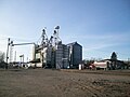 Grain storage and rail line
 -
 Rail bridge over the Nooksack River


Transportation
[edit]The main highway serving Ferndale is Interstate 5. The town is also bisected by the BNSF Railway, which provides freight service and carries Amtrak Cascades passenger trains.
Sister city
[edit]Ferndale has the following sister city relationship:
 Minamibōsō, Chiba Prefecture, Japan.[16]
Notable people
[edit]- Jesse Brand – Nashville songwriter, musician, and actor
- Dennis Erickson – Retired college football and NFL head coach
- Sky Hopinka - Filmmaker, MacArthur grant recipient, poet
- Michael Koenen – Former punter for the Tampa Bay Buccaneers
- Jake Locker – Former NFL quarterback for the Tennessee Titans
- Daran Norris – actor, most notably for voice work and a recurring role on the television series Veronica Mars
- Doug Pederson – Former NFL quarterback, head coach of the Jacksonville Jaguars
- Wendy B. Lawrence – Former NASA astronaut,[17] former captain in the US Navy
References
[edit]- ^ a b "2023 U.S. Gazetteer Files". United States Census Bureau. Retrieved August 21, 2024.
- ^ a b U.S. Geological Survey Geographic Names Information System: Ferndale, Washington
- ^ a b c "Explore Census Data". United States Census Bureau. Retrieved August 21, 2024.
- ^ a b c "City and Town Population Totals: 2020-2023". United States Census Bureau. August 21, 2024. Retrieved August 21, 2024.
- ^ Sam Taylor (April 28, 2008). "Ferndale Skatepark lightning rod volunteer also manning anti-school bond campaign". The Bellingham Herald. Retrieved October 18, 2008.[dead link]
- ^ Moles, Kathleen (July 20, 2014). "Ferndale — Thumbnail History". HistoryLink. Retrieved October 22, 2023.
- ^ "History of the City". ferndale.civicweb.net. City of Ferndale, Washington. 2012.
- ^ Majors, Harry M. (1975). Exploring Washington. Van Winkle Publishing Co. p. 20. ISBN 978-0-918664-00-6.
- ^ "Comparison of the Average Weather in Ferndale, Bellingham, and Lynden - Weather Spark". weatherspark.com. Retrieved July 20, 2020.
- ^ "Census of Population and Housing". United States Census Bureau. Retrieved June 4, 2015.
- ^ "P2 HISPANIC OR LATINO, AND NOT HISPANIC OR LATINO BY RACE – 2020: DEC Redistricting Data (PL 94-171) – Ferndale city, Washington".
- ^ "US Census Bureau, Table P16: Household Type". United States Census Bureau. Retrieved August 21, 2024.
- ^ "How many people live in Ferndale city, Washington". USA Today. Retrieved August 21, 2024.
- ^ Wahba, Phil (February 1, 2018). "A Kindred Sole". Fortune (Print edition): 30. ISSN 0015-8259.
- ^ Gallagher, Dave (April 22, 2020). "Alcoa to close Intalco Works smelter near Ferndale, lays off around 700 employees". Retrieved August 24, 2020.
- ^ "Washington Sister Cities". Lieutenant Governor Cyrus Habib. Retrieved July 20, 2020.
- ^ "Events and Programs - DGA19 Bio Lawrence - www.usna.com". www.usna.com. Archived from the original on May 17, 2021.
External links
[edit] Media from Commons
 Travel information from Wikivoyage
Municipalities and communities of Whatcom County, Washington, United States | ||
|---|---|---|
| Cities |  | |
| CDPs | ||
| Indian reservations | ||
| Unincorporated communities | ||
| Ghost towns | ||
| International | |
|---|---|
| National | |
| Geographic | |
| Other | |