
Vefsn
Vefsn Municipality
Vefsn kommune | |
|---|---|
| Vefsen herred (historic name) | |
 | |
 Flag | |
 Nordland within Norway | |
 Vefsn within Nordland | |
| Coordinates: 65°47′57″N 13°15′02″E / 65.79917°N 13.25056°E | |
| Country | Norway |
| County | Nordland |
| District | Helgeland |
| Established | 1 Jan 1838 |
| Administrative centre | Mosjøen |
| Government | |
| • Mayor (2023) | Rune Krutå (Ap) |
| Area | |
| • Total | 1,929.39 km2 (744.94 sq mi) |
| • Land | 1,838.13 km2 (709.71 sq mi) |
| • Water | 91.27 km2 (35.24 sq mi) 4.7% |
| • Rank | #41 in Norway |
| Population (2023) | |
| • Total | 13,342 |
| • Rank | #91 in Norway |
| • Density | 7.3/km2 (19/sq mi) |
| • Change (10 years) | |
| Demonym | Vefsning[1] |
| Official language | |
| • Norwegian form | Neutral |
| Time zone | UTC+01:00 (CET) |
| • Summer (DST) | UTC+02:00 (CEST) |
| ISO 3166 code | NO-1824[3] |
| Website | Official website |

Vefsn (Southern Sami: Vaapste) is a municipality in Nordland county, Norway. It is part of the Helgeland traditional region. The administrative centre of the municipality is the town of Mosjøen (population: 9,843). Some of the notable villages in Vefsn include Drevvassbygda, Elsfjord, and Husvik.
The 1,929-square-kilometre (745 sq mi) municipality is the 41st largest by area out of the 356 municipalities in Norway. Vefsn is the 91st most populous municipality in Norway with a population of 13,342. The municipality's population density is 7.3 inhabitants per square kilometre (19/sq mi) and its population has increased by 0.7% over the previous 10-year period.[4][5]
History
[edit]
The municipality of Vefsn was established on 1 January 1838 (see formannskapsdistrikt law). In 1862, the vast eastern district of Vefsn (population: 921) was separated from Vefsn to become the new municipality of Hattfjelldal. This left Vefsn with 5,051 residents. In 1876, the town of Mosjøen (population: 379) was separated from Vefsn to become a separate municipality. This left Vefsn with 4,672 residents.
In 1927, Vefsn municipality was split into three: the small northern district (population: 964) became the new municipality of Drevja and the large southern district (population: 1,746) became the new municipality of Grane. After the split, Vefsn had 3,119 residents remaining. In 1939, a small area of Vefsn (population: 45) was transferred to neighboring town of Mosjøen.
During the 1960s, there were many municipal mergers across Norway due to the work of the Schei Committee. On 1 January 1962, the municipality of Vefsn (population: 5,358) was merged with the neighboring town of Mosjøen (population: 4,628) and the neighboring municipalities of Drevja (population: 1,001) and Elsfjord (population: 920) to form a new, larger municipality of Vefsn. On 1 January 1995, the mainland areas of the neighboring Alstahaug Municipality (population: 70) were transferred to Vefsn.[6]
Name
[edit]
The municipality (originally the parish) is named after the river Vefsna (Old Norse: Vefsnar) which flows through the municipality into the Vefsnfjorden (Old Norse: Vefsnir). The meaning of the river name is unknown, but it possibly comes from the old word vefja which means "to wrap" or "to wind around".[7] Historically, the name of the municipality was spelled Vefsen. On 3 November 1917, a royal resolution changed the spelling of the name of the municipality to Vefsn.[8]
Coat of arms
[edit]The coat of arms was granted on 13 September 1974. The official blazon is "Sable, a rooster argent armed gules" (Norwegian: På svart bunn en sølv hane). This means the arms have a black field (background) and the charge is a rooster. The rooster has a tincture of argent which means it is commonly colored white, but if it is made out of metal, then silver is used. The rooster is also armed which means its claws, beak, and comb are colored red. The rooster is a symbol for watchfulness and alertness. The arms were designed by Arthur Gustavsson.[9][10][11]
The coat of arms was originally adopted by the municipality of Mosjøen on 25 March 1960. In 1962, Mosjøen was merged with Vefsn, Drevja, and Elsfjord to form a new, larger Vefsn municipality. After the merger, the old arms of Mosjøen were chosen for the new municipality. Since the arms officially became obsolete after the merger, they were re-granted in 1974.[10]
Churches
[edit]The Church of Norway has three parishes (sokn) within the municipality of Vefsn. It is part of the Indre Helgeland prosti (deanery) in the Diocese of Sør-Hålogaland.
| Parish (sokn) | Church name | Location of the church | Year built |
|---|---|---|---|
| Dolstad | Dolstad Church | Mosjøen | 1735 |
| Drevja | Drevja Church | Drevja | 1883 |
| Elsfjord | Elsfjord Church | Elsfjord | 1955 |
Geography
[edit]The administrative centre of Vefsn is the town of Mosjøen which is situated along the innermost part of the Vefsnfjorden. Outside Mosjøen, the large municipality of Vefsn is dominated by spruce forests, mountains, lakes, agriculture, and the Vefsna river. The municipality is served by Mosjøen Airport, Kjærstad.
The mountain Lukttinden is located in the northern part of the municipality. There are many large lakes in Vefsn including Drevvatnet, Finnknevatnet, Fustvatnet, Hundålvatnet, Luktvatnet, Mjåvatnet, and Ømmervatnet. The Lomsdal–Visten National Park is partially located in Vefsn.
Birdlife
[edit]The bird watcher that visits Vefsn soon realizes that it will take more than a day to cover all the interesting habitats and birding areas. Here you will find areas of virtually untouched coniferous woodlands, both inland and along the coast. The Skjørlegda nature reserve is a good example of woodland protection. Here you will find a virtually untouched coniferous forest covering the Eiterå valley. The valley stretches inland to a higher mountainous habitat that is also worth checking.
-
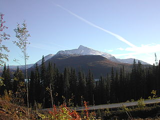 Luktinden (mountain) in autumn
 -
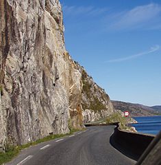 The road along Vefsnfjord
 -
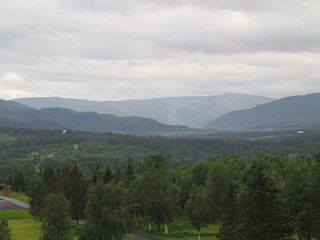 Drevje valley (Drevjedalen), Vefsn


Government
[edit]All municipalities in Norway are responsible for primary education (through 10th grade), outpatient health services, senior citizen services, welfare and other social services, zoning, economic development, and municipal roads and utilities. The municipality is governed by a municipal council of directly elected representatives. The mayor is indirectly elected by a vote of the municipal council.[12] The municipality is under the jurisdiction of the Helgeland District Court and the Hålogaland Court of Appeal.
Municipal council
[edit]The municipal council (Kommunestyre) of Vefsn is made up of 29 representatives that are elected to four year terms. The tables below show the current and historical composition of the council by political party.
| Party name (in Norwegian) | Number of representatives | |
|---|---|---|
| Labour Party (Arbeiderpartiet) | 9 | |
| Progress Party (Fremskrittspartiet) | 5 | |
| Conservative Party (Høyre) | 8 | |
| Red Party (Rødt) | 2 | |
| Centre Party (Senterpartiet) | 3 | |
| Socialist Left Party (Sosialistisk Venstreparti) | 1 | |
| Vefsn Cross-Politics Party (Vefsn tverrpolitiske parti) | 1 | |
| Total number of members: | 29 | |
| Party name (in Norwegian) | Number of representatives | |
|---|---|---|
| Labour Party (Arbeiderpartiet) | 8 | |
| Progress Party (Fremskrittspartiet) | 2 | |
| Conservative Party (Høyre) | 3 | |
| Red Party (Rødt) | 3 | |
| Centre Party (Senterpartiet) | 10 | |
| Socialist Left Party (Sosialistisk Venstreparti) | 2 | |
| Vefsn Cross-Politics Party (Vefsn tverrpolitiske parti) | 1 | |
| Total number of members: | 29 | |
| Party name (in Norwegian) | Number of representatives | |
|---|---|---|
| Labour Party (Arbeiderpartiet) | 10 | |
| Progress Party (Fremskrittspartiet) | 2 | |
| Conservative Party (Høyre) | 5 | |
| Red Party (Rødt) | 4 | |
| Centre Party (Senterpartiet) | 2 | |
| Socialist Left Party (Sosialistisk Venstreparti) | 1 | |
| Liberal Party (Venstre) | 2 | |
| Vefsn Cross-Politics Party (Vefsn tverrpolitiske parti) | 3 | |
| Total number of members: | 29 | |
| Party name (in Norwegian) | Number of representatives | |
|---|---|---|
| Labour Party (Arbeiderpartiet) | 15 | |
| Progress Party (Fremskrittspartiet) | 6 | |
| Conservative Party (Høyre) | 4 | |
| Christian Democratic Party (Kristelig Folkeparti) | 1 | |
| Red Party (Rødt) | 3 | |
| Centre Party (Senterpartiet) | 3 | |
| Socialist Left Party (Sosialistisk Venstreparti) | 1 | |
| Liberal Party (Venstre) | 2 | |
| Total number of members: | 35 | |
| Party name (in Norwegian) | Number of representatives | |
|---|---|---|
| Labour Party (Arbeiderpartiet) | 16 | |
| Progress Party (Fremskrittspartiet) | 6 | |
| Conservative Party (Høyre) | 2 | |
| Christian Democratic Party (Kristelig Folkeparti) | 1 | |
| Red Electoral Alliance (Rød Valgallianse) | 3 | |
| Centre Party (Senterpartiet) | 3 | |
| Socialist Left Party (Sosialistisk Venstreparti) | 3 | |
| Liberal Party (Venstre) | 1 | |
| Total number of members: | 35 | |
| Party name (in Norwegian) | Number of representatives | |
|---|---|---|
| Labour Party (Arbeiderpartiet) | 15 | |
| Progress Party (Fremskrittspartiet) | 6 | |
| Conservative Party (Høyre) | 2 | |
| Christian Democratic Party (Kristelig Folkeparti) | 1 | |
| Red Electoral Alliance (Rød Valgallianse) | 2 | |
| Centre Party (Senterpartiet) | 3 | |
| Socialist Left Party (Sosialistisk Venstreparti) | 5 | |
| Liberal Party (Venstre) | 1 | |
| Total number of members: | 35 | |
| Party name (in Norwegian) | Number of representatives | |
|---|---|---|
| Labour Party (Arbeiderpartiet) | 14 | |
| Progress Party (Fremskrittspartiet) | 4 | |
| Conservative Party (Høyre) | 5 | |
| Christian Democratic Party (Kristelig Folkeparti) | 2 | |
| Red Electoral Alliance (Rød Valgallianse) | 1 | |
| Centre Party (Senterpartiet) | 4 | |
| Socialist Left Party (Sosialistisk Venstreparti) | 4 | |
| Liberal Party (Venstre) | 1 | |
| Total number of members: | 35 | |
| Party name (in Norwegian) | Number of representatives | |
|---|---|---|
| Labour Party (Arbeiderpartiet) | 17 | |
| Progress Party (Fremskrittspartiet) | 2 | |
| Conservative Party (Høyre) | 4 | |
| Christian Democratic Party (Kristelig Folkeparti) | 2 | |
| Centre Party (Senterpartiet) | 5 | |
| Socialist Left Party (Sosialistisk Venstreparti) | 3 | |
| Liberal Party (Venstre) | 2 | |
| Total number of members: | 35 | |
| Party name (in Norwegian) | Number of representatives | |
|---|---|---|
| Labour Party (Arbeiderpartiet) | 16 | |
| Conservative Party (Høyre) | 5 | |
| Christian Democratic Party (Kristelig Folkeparti) | 1 | |
| Centre Party (Senterpartiet) | 4 | |
| Socialist Left Party (Sosialistisk Venstreparti) | 8 | |
| Liberal Party (Venstre) | 1 | |
| Total number of members: | 35 | |
| Party name (in Norwegian) | Number of representatives | |
|---|---|---|
| Labour Party (Arbeiderpartiet) | 32 | |
| Conservative Party (Høyre) | 9 | |
| Christian Democratic Party (Kristelig Folkeparti) | 2 | |
| Centre Party (Senterpartiet) | 4 | |
| Socialist Left Party (Sosialistisk Venstreparti) | 4 | |
| Liberal Party (Venstre) | 2 | |
| Total number of members: | 53 | |
| Party name (in Norwegian) | Number of representatives | |
|---|---|---|
| Labour Party (Arbeiderpartiet) | 32 | |
| Christian Democratic Party (Kristelig Folkeparti) | 5 | |
| Centre Party (Senterpartiet) | 9 | |
| Socialist Left Party (Sosialistisk Venstreparti) | 4 | |
| Liberal Party (Venstre) | 3 | |
| Total number of members: | 53 | |
| Party name (in Norwegian) | Number of representatives | |
|---|---|---|
| Labour Party (Arbeiderpartiet) | 27 | |
| Conservative Party (Høyre) | 12 | |
| Christian Democratic Party (Kristelig Folkeparti) | 3 | |
| Red Electoral Alliance (Rød Valgallianse) | 1 | |
| Centre Party (Senterpartiet) | 6 | |
| Liberal Party (Venstre) | 4 | |
| Total number of members: | 53 | |
| Party name (in Norwegian) | Number of representatives | |
|---|---|---|
| Labour Party (Arbeiderpartiet) | 27 | |
| Conservative Party (Høyre) | 6 | |
| Christian Democratic Party (Kristelig Folkeparti) | 4 | |
| Centre Party (Senterpartiet) | 9 | |
| Socialist Left Party (Sosialistisk Venstreparti) | 4 | |
| Liberal Party (Venstre) | 3 | |
| Total number of members: | 53 | |
| Party name (in Norwegian) | Number of representatives | |
|---|---|---|
| Labour Party (Arbeiderpartiet) | 29 | |
| Conservative Party (Høyre) | 4 | |
| Christian Democratic Party (Kristelig Folkeparti) | 3 | |
| Centre Party (Senterpartiet) | 9 | |
| Socialist People's Party (Sosialistisk Folkeparti) | 4 | |
| Liberal Party (Venstre) | 4 | |
| Total number of members: | 53 | |
| Party name (in Norwegian) | Number of representatives | |
|---|---|---|
| Labour Party (Arbeiderpartiet) | 27 | |
| Conservative Party (Høyre) | 5 | |
| Christian Democratic Party (Kristelig Folkeparti) | 2 | |
| Centre Party (Senterpartiet) | 8 | |
| Socialist People's Party (Sosialistisk Folkeparti) | 5 | |
| Liberal Party (Venstre) | 6 | |
| Total number of members: | 53 | |
| Party name (in Norwegian) | Number of representatives | |
|---|---|---|
| Labour Party (Arbeiderpartiet) | 29 | |
| Conservative Party (Høyre) | 6 | |
| Christian Democratic Party (Kristelig Folkeparti) | 2 | |
| Centre Party (Senterpartiet) | 8 | |
| Socialist People's Party (Sosialistisk Folkeparti) | 2 | |
| Liberal Party (Venstre) | 6 | |
| Total number of members: | 53 | |
| Party name (in Norwegian) | Number of representatives | |
|---|---|---|
| Labour Party (Arbeiderpartiet) | 13 | |
| Conservative Party (Høyre) | 1 | |
| Centre Party (Senterpartiet) | 7 | |
| Liberal Party (Venstre) | 1 | |
| Local List(s) (Lokale lister) | 1 | |
| Total number of members: | 23 | |
| Party name (in Norwegian) | Number of representatives | |
|---|---|---|
| Labour Party (Arbeiderpartiet) | 13 | |
| Farmers' Party (Bondepartiet) | 7 | |
| Liberal Party (Venstre) | 2 | |
| Local List(s) (Lokale lister) | 1 | |
| Total number of members: | 23 | |
| Party name (in Norwegian) | Number of representatives | |
|---|---|---|
| Labour Party (Arbeiderpartiet) | 13 | |
| Farmers' Party (Bondepartiet) | 5 | |
| Liberal Party (Venstre) | 2 | |
| Total number of members: | 20 | |
| Party name (in Norwegian) | Number of representatives | |
|---|---|---|
| Labour Party (Arbeiderpartiet) | 12 | |
| Communist Party (Kommunistiske Parti) | 1 | |
| Farmers' Party (Bondepartiet) | 6 | |
| Liberal Party (Venstre) | 1 | |
| Total number of members: | 20 | |
| Party name (in Norwegian) | Number of representatives | |
|---|---|---|
| Labour Party (Arbeiderpartiet) | 12 | |
| Farmers' Party (Bondepartiet) | 6 | |
| Liberal Party (Venstre) | 2 | |
| Total number of members: | 20 | |
| Party name (in Norwegian) | Number of representatives | |
|---|---|---|
| Labour Party (Arbeiderpartiet) | 12 | |
| Communist Party (Kommunistiske Parti) | 7 | |
| Farmers' Party (Bondepartiet) | 1 | |
| Total number of members: | 20 | |
| Note: Due to the German occupation of Norway during World War II, no elections were held for new municipal councils until after the war ended in 1945. | ||
Mayors
[edit]- 1838–1842: Christian Quale
- 1842–1844: Kristoffer Ingebrigtsen
- 1844–1862: Ola Olsson
- 1863–1864: Peter Holst
- 1865–1866: Ola Olsson
- 1867–1870: Anders Persson
- 1871–1876: John Ottesen
- 1877–1878: Even Sund
- 1889–1894: Peter Holst
- 1895–1896: Nils M. Kulstad
- 1897–1898: Even Sund
- 1899–1901: Per Flaa (LL)
- 1902–1904: Nils Kulstad (V)
- 1905-1905: Christian Møinichen Havig (V)
- 1905-1905: Per Flaa (LL)
- 1905–1913: Ole Klemmentsen (V)
- 1914–1916: Mikkel Alsgaard (V)
- 1917–1918: Nils Skandfer
- 1919-1920: Sølfest Hagen
- 1920–1925: Nils Mjaavatn
- 1926–1928: Anders Svare (V)
- 1929–1940: Per M. Stordal (Ap)
- 1943–1945: Anders Svare
- 1946-1946: Kåre Vangen
- 1946–1947: Arne Aalbotsjord (Ap)
- 1948–1954: Anders Granås
- 1954–1955: Arne Aalbotsjord (Ap)
- 1956-1959: Kåre Vangen
- 1960-1961: Arne Aalbotsjord (Ap)
- 1962-1966: Einar Jensen (Ap)
- 1966–1975: Arne Aalbotsjord (Ap)
- 1976–1979: Eugen Almås (Ap)
- 1980-1989: Peder Hyttebakk (Ap)
- 1990-1993: Roy Skogsholm (Ap)
- 1993-1998: Knut Petter Torgersen (Ap)
- 1998-2000: Britt Jonassen (Ap)
- 2000-2019: Jann-Arne Løvdahl (Ap)
- 2019–2023: Berit Hundåla (Sp)
- 2023–present: Rune Krutå (Ap)
Notable people
[edit]Notable people that were born or lived in Vefsn include:


- Thorolf Holmboe (1866 in Vefsn –1935), a painter, illustrator, and designer
- Nils Mjaavatn (1883 in Vefsn – 1951), a farmer, teacher, and politician
- David Monrad Johansen (1888 in Vefsn – 1974), a composer
- Aage Grundstad (1923 in Vefsn – 2012), an award-winning accordion player[33]
- Erling Bauck (1924 in Mosjøen – 2004), a Norwegian resistance member and writer
- Kjell Eliassen (born 1929 in Vefsn), a diplomat
- Trond Øyen (1929 in Mosjøen – 1999), a Norwegian violinist
- Baard Owe (1936 in Mosjøen – 2017), an actor, moved to Denmark in 1956[34]
- Inga Juuso (1945 in Mosjøen – 2014), a yoiker, Sami singer and actress[35]
- Odd Eriksen (born 1955; worked in Mosjøen), a politician also known for stopping an Algerian hijacker from crashing a Kato Air-flight in 2004.
- Frode Fjellheim (born 1959 in Mussere), a yoiker and musician on piano and synthesizer
- Finn Guttormsen (born 1968 in Mosjøen), a Jazz musician on upright bass
- Aleksander L. Nordaas (born 1982 in Mosjøen), a screenwriter and film director[36]
- Silje Reinåmo (born 1982 in Mosjøen), an actress, dancer, and musical performer[37]
- Sandra Lyng (born 1987 in Mosjøen), a Norwegian singer
Sport
[edit]- Johan Lind (born 1942 in Mosjøen), a speed skater who competed at the 1968 and 1972 Winter Olympics
- Bent Inge Johnsen (born 1972 in Mosjøen), a former footballer with 284 club caps and assistant manager
- Anette Sagen (born 1985 in Mosjøen), a Norwegian former ski jumper
- Thomas Drage (born 1992 in Mosjøen), a football player with over 220 club caps
Farms of Vefsn
[edit]Map of the farms of Vefsn
[edit]Coordinates are approximate.
Note that each map has a maximum number of listings it can display, so the map has been divided into parts consistent with the enumeration districts (tellingskrets) in the 1920 census. This map will include one farm name per farm number; other farm names or subdivision numbers may exist.
The municipalities of Mosjøen, Elsfjord, and Drevja were incorporated into Vefsn in 1962, and are not included in these maps. Tellingskrets 5, Granli; 6 Øvre Svenningdal, and 7 Austervefsen og Feplingdal, are now part of other municipalities, primarily Grane.

2.5miles
Tellingskrets (enumeration districts): 1, Hunnaala (lime); 2, Vikdalen (black); 3, Nes og Mo Skolekrinsar (blue); 4, Forsjord (purple); 8, Bjørnådalen (green); 10, Hals (red).

1.2miles
Tellingskrets (enumeration districts): 9, Austerbygden og Marka (teal); 11, Helfjell og Herringen (blue)

1.2miles
Tellingskrets (enumeration districts): 12, Ømmervatnet og Fustvatnet (lime); 13, Øvre Drevjen (red); 14, Ner Drevjen (blue); 15, Skaland (green).
Farm names and numbers
[edit]Following are the farms in the Vefsn municipality, as they are listed in O. Rygh's series Norske_Gaardnavne ("Norwegian farm names"), the Nordland volume of which was published in 1905. Here is the digital version of that volume: <Norske_gaardnavne_bd_Nordlands>
The farm numbers are used in some census records, and numbers that are near each other indicate that those farms are geographically proximate. Handwritten Norwegian sources, particularly those prior to 1800, may use variants on these names. For recorded variants before 1723, see the digital version of O. Rygh. Note that the 1920 census records mapped above may not match O. Rygh.
Farm names were often used as part of Norwegian names, in addition to the person's given name and patronymic or inherited surname. Some families retained the farm name, or toponymic, as a surname when they emigrated, so in those cases tracing a surname may tell you specifically where in Norway the family was from. This tradition began to change in the mid to late 19th century, and inherited surnames were codified into law in 1923.
| Farm Name | Farm Number |
| Juviken | 1 |
| Grønviken | 2 |
| Søttaren | 3 |
| Øren | 4 |
| Kleven | 5 |
| Sørgaarden | 6, 1 |
| Hundaala, 1 | 6, 7 |
| Hundaala, 2 | 7 |
| Høinesdalen | 8 |
| Digermulen | 9 |
| Demmeldalen | 10 |
| Hundaalvatnet | 11 |
| Bjørnvolden | 12 |
| Sørvasdale | 13 |
| Vikdalen | 14 |
| Øien | 15 |
| Rotneset | 15, 5 |
| Kvandalen | 16 |
| Tveraaen | 17 |
| Kjærstad | 18 |
| Helvik | 18, 2 |
| Rosvold | 19 |
| Aufles | 20 |
| Grøva | 21 |
| Kvalfors | 22 |
| Forsjorden | 23 |
| Øksendalen | 24 |
| Steinlien | 25 |
| Eiteraaen øvre | 26 |
| Eiteraaen nedre | 27 |
| Eiteraaen vestre | 28 |
| Eiteraaholmen | 29 |
| Tverelvmoen | 30 |
| Skjørlægden | 31 |
| Eiteraafjeldet | 32 |
| Ravnaaen | 33 |
| Turmoen | 34 |
| Faldmoen | 35 |
| Spelremmen | 36 |
| Laksfors, 1 | 37 |
| Laksfors, 2 | 38 |
| Laksforshoved | 39 |
| Spelen | 40 |
| Valryggen | 41 |
| Finsaasen | 42 |
| Glugvaselven | 43 |
| Haustreisdalen, 1 | 44 |
| Haustreisdalen, 2 | 45 |
| Nygaarden | 46 |
| Glugvatnet | 47 |
| Grane | 48 |
| Almdalen | 49 |
| Svenningdalen nedre | 50 |
| Baafjeldmoen | 51 |
| Stavasdalen | 52 |
| Baafjelddalen | 53 |
| Svenningdalen øvre | 54 |
| Hjortskarmoen, 1 | 55 |
| Kapskarmoen | 56 |
| Hjortskarmoen, 2 | 57 |
| Holmvasdalen | 58 |
| Bjørkaasen | 59 |
| Kjerringvatnet | 60 |
| Kapfjeldlien | 61 |
| Storkjønlien | 62 |
| Tomasvatnet | 63 |
| Bjorkjønlien | 64 |
| Kvanlien | 65 |
| Tøimskarlien | 66 |
| Bustadmoen | 67 |
| Simskaret | 68 |
| Fiplingkroken | 69 |
| Fiplingdalen, 1 | 70 |
| Fiplingdalen, 2 | 71 |
| Forshaugen | 72 |
| Jerpaasen | 73 |
| Hallingen | 74 |
| Fagerlien | 75 |
| Klovimoen | 76 |
| Bjorbækmoen | 77 |
| Stillelvaasen | 78 |
| Svartvatnet | 79 |
| Stabforsmoen | 80 |
| Stormoen | 81 |
| Baafjeldmoen østre | 82 |
| Fjeldbækmoen | 83 |
| Herringbotnet | 84 |
| Lien | 84, 1 |
| Nergaarden | 84, 2 |
| Kalvmoen | 85 |
| Skjaamoen | 86 |
| Kjønnaasen | 87 |
| Kjemsaasen | 88 |
| Killeraasen | 89 |
| Reinfjeldet | 90 |
| Lian | 90, 1 |
| Nordaasen | 91 |
| Klubben | 91, 3 |
| Langvatnet | 92 |
| Aasen | 93 |
| Ravatnet | 94 |
| Ravasbakken | 94, 1 |
| Fokstad | 94, 3 |
| Nordstad | 94, 4 |
| Alsgaarden | 95 |
| Bjørnaaen øvre | 96 |
| Einremmen | 96, 3 |
| Bjørnaalien | 97 |
| Skogsaasen | 98 |
| Bjørnaaen nedre | 99 |
| Mosaasen | 100 |
| Skog, 1 | 101 |
| Kringleøren | 101, 2 |
| Øvstenget | 101, 6 |
| Skog, 2 | 102 |
| Mo | 103 |
| Husbrekken | 103, 2 |
| Myrbakken | 103, 3 |
| Nyrud | 103, 5 |
| Dolstad | 104 |
| Hals | 105 |
| Halsøen | 105, 2 |
| Andaas | 106 |
| Remmen | 107 |
| Hagfors | 108 |
| Moldremmen | 109 |
| Marken øvre | 110 |
| Gamarken | 111 |
| Røsdalen | 112 |
| Midtmarken indre | 113 |
| Midtmarken ytre | 114 |
| Jakobgaardshaugen | 114, 2 |
| Marken nedre | 115 |
| Aalbosjorden | 116 |
| Fjeldstad | 116, 2 |
| Kulstad | 117 |
| Aasen | 117, 1 |
| Baathølen | 117, 2 |
| Myren | 117, 3 |
| Dalenget | 117, 4 |
| Staurremmen | 117, 8 |
| Fustskotremmen, 1 | 117, 9 |
| Trangdalen | 117, 10 |
| Fustskotremmen, 2 | 117, 11 |
| Finbrauten | 117, 12 |
| Kulstadsjøen | 117, 16 |
| Rynes | 118 |
| Bøen | 118, 4 |
| Aaremmen | 119 |
| Katuglehaugen | 120 |
| Veset | 121 |
| Forsmoen indre | 122 |
| Jomfruremmen | 123 |
| Haukland | 124 |
| Gløsen | 124, 3 |
| Volden | 125 |
| Bjørknes | 126 |
| Risnes | 127 |
| Myrnes | 128 |
| Aanes | 129 |
| Svartaasen | 130 |
| Steffenremmen | 131 |
| Herring mellem | 132 |
| Nilsmoen | 133 |
| Almdalen | 134 |
| Østerherring øvre | 135 |
| Østerherring nedre | 136 |
| Stien | 137 |
| Lillesmedseng øvre | 138 |
| Lillesmedseng nedre | 139 |
| Storsmedseng | 140 |
| Lynghaugen | 140, 2 |
| Strøm | 141 |
| Jordbæksletten | 142 |
| Breivik | 143 |
| Aspnes | 144 |
| Aakviken | 145 |
| Langmoen, 1 | 146 |
| Langmoen, 2 | 147 |
| Engaasen | 148 |
| Rokaasen | 149 |
| Granaasen | 150 |
| Hellefjeld ytre | 151 |
| Storremmen | 151, 1 |
| Utgaarden | 151, 2 |
| Husremmen | 151, 3 |
| Hellefjeld mellem | 152 |
| Hellefjeld øvre | 153 |
| Guldmoen | 154 |
| Høglien | 155 |
| Groftremmen | 156 |
| Skjetviken | 157 |
| Sovarneset | 158 |
| Mjaavatnet, 1 | 159 |
| Gofahaugen | 159, 1 |
| Mjaavatnet, 2 | 160 |
| Strømsnes | 161 |
| Tuvneset | 162 |
| Troldaasuren | 163 |
| Ømmervashoved | 164 |
| Næverveien med Kaldaahaugen | 165 |
| Hatten | 166 |
| Angermoen | 167 |
| Stordalen | 168 |
| Bjørkremmen | 169 |
| Sandbugten | 170 |
| Almlien | 171 |
| Ømmervasbugten | 172 |
| Perjorden | 173 |
| Blaafjeldet | 174 |
| Blaafjelddalen | 175 |
| Steinhaugen | 176 |
| Smalboremmen | 177 |
| Rognryggen | 178 |
| Vashoved | 179 |
| Tømmermyrmoen | 180 |
| Myrmoen | 181 |
| Bratlien | 182 |
| Kummerneset | 183 |
| Kummermoen | 184 |
| Breimoen | 185 |
| Baatstrand | 186 |
| Trømoen | 186, 1 |
| Trøen | 186, 2 |
| Øigaarden | 186, 3 |
| Almaasen | 187 |
| Lamoen | 188 |
| Granmoen | 189 |
| Strøm | 190 |
| Moen | 190, 1 |
| Myren | 190, 2 |
| Nystad | 190, 6 |
| Forsmoen ytre | 191 |
| Bratbakken | 192 |
| Bergsnev | 193 |
| Nyland indre | 194 |
| Stuvland | 195 |
| Drevland | 196 |
| Utnes | 197 |
| Holand | 198 |
| Myrmoen | 198, 3 |
| Lindset | 199 |
| Fornesviken | 199, 4 |
| Søfting | 200 |
| Skaland | 201 |
| Staulan | 201, 1 |
See also
[edit]References
[edit]- ^ "Navn på steder og personer: Innbyggjarnamn" (in Norwegian). Språkrådet.
- ^ "Forskrift om målvedtak i kommunar og fylkeskommunar" (in Norwegian). Lovdata.no.
- ^ Bolstad, Erik; Thorsnæs, Geir, eds. (26 January 2023). "Kommunenummer". Store norske leksikon (in Norwegian). Kunnskapsforlaget.
- ^ Statistisk sentralbyrå. "Table: 06913: Population 1 January and population changes during the calendar year (M)" (in Norwegian).
- ^ Statistisk sentralbyrå. "09280: Area of land and fresh water (km²) (M)" (in Norwegian).
- ^ Jukvam, Dag (1999). "Historisk oversikt over endringer i kommune- og fylkesinndelingen" (PDF) (in Norwegian). Statistisk sentralbyrå.
- ^ Rygh, Oluf (1905). Norske gaardnavne: Nordlands amt (in Norwegian) (16 ed.). Kristiania, Norge: W. C. Fabritius & sønners bogtrikkeri. p. 64.
- ^ "Norsk Lovtidende. 2den Afdeling. 1917. Samling af Love, Resolutioner m.m". Norsk Lovtidend (in Norwegian). Kristiania, Norge: Grøndahl og Søns Boktrykkeri: 1057–1065. 1917.
- ^ "Civic heraldry of Norway - Norske Kommunevåpen". Heraldry of the World. Retrieved 4 February 2023.
- ^ a b "Vefsn, Nordland (Norway)". Flags of the World. Retrieved 4 February 2023.
- ^ "Godkjenning av våpen og flagg". Lovdata.no (in Norwegian). Norges kommunal- og arbeidsdepartementet. 13 September 1974. Retrieved 4 February 2023.
- ^ Hansen, Tore; Vabo, Signy Irene, eds. (20 September 2022). "kommunestyre". Store norske leksikon (in Norwegian). Kunnskapsforlaget. Retrieved 14 October 2022.
- ^ "Kommunestyrevalg 2023 - Nordland". Valg Direktoratet. Retrieved 27 December 2023.
- ^ "Tall for Norge: Kommunestyrevalg 2019 - Nordland". Valg Direktoratet. Retrieved 28 October 2019.
- ^ a b c d "Table: 04813: Members of the local councils, by party/electoral list at the Municipal Council election (M)" (in Norwegian). Statistics Norway.
- ^ "Tall for Norge: Kommunestyrevalg 2011 - Nordland". Valg Direktoratet. Retrieved 28 October 2019.
- ^ "Kommunestyrevalget 1995" (PDF) (in Norwegian). Oslo-Kongsvinger: Statistisk sentralbyrå. 1996. Retrieved 2 April 2020.
- ^ "Kommunestyrevalget 1991" (PDF) (in Norwegian). Oslo-Kongsvinger: Statistisk sentralbyrå. 1993. Retrieved 2 April 2020.
- ^ "Kommunestyrevalget 1987" (PDF) (in Norwegian). Oslo-Kongsvinger: Statistisk sentralbyrå. 1988. Retrieved 2 April 2020.
- ^ "Kommunestyrevalget 1983" (PDF) (in Norwegian). Oslo-Kongsvinger: Statistisk sentralbyrå. 1984. Retrieved 2 April 2020.
- ^ "Kommunestyrevalget 1979" (PDF) (in Norwegian). Oslo: Statistisk sentralbyrå. 1979. Retrieved 2 April 2020.
- ^ "Kommunevalgene 1975" (PDF) (in Norwegian). Oslo: Statistisk sentralbyrå. 1977. Retrieved 2 April 2020.
- ^ "Kommunevalgene 1972" (PDF) (in Norwegian). Oslo: Statistisk sentralbyrå. 1973. Retrieved 2 April 2020.
- ^ "Kommunevalgene 1967" (PDF) (in Norwegian). Oslo: Statistisk sentralbyrå. 1967. Retrieved 2 April 2020.
- ^ "Kommunevalgene 1963" (PDF) (in Norwegian). Oslo: Statistisk sentralbyrå. 1964. Retrieved 2 April 2020.
- ^ "Kommunevalgene og Ordførervalgene 1959" (PDF) (in Norwegian). Oslo: Statistisk sentralbyrå. 1960. Retrieved 2 April 2020.
- ^ "Kommunevalgene og Ordførervalgene 1955" (PDF) (in Norwegian). Oslo: Statistisk sentralbyrå. 1957. Retrieved 2 April 2020.
- ^ "Kommunevalgene og Ordførervalgene 1951" (PDF) (in Norwegian). Oslo: Statistisk sentralbyrå. 1952. Retrieved 2 April 2020.
- ^ "Kommunevalgene og Ordførervalgene 1947" (PDF) (in Norwegian). Oslo: Statistisk sentralbyrå. 1948. Retrieved 2 April 2020.
- ^ "Kommunevalgene og Ordførervalgene 1945" (PDF) (in Norwegian). Oslo: Statistisk sentralbyrå. 1947. Retrieved 2 April 2020.
- ^ "Kommunevalgene og Ordførervalgene 1937" (PDF) (in Norwegian). Oslo: Statistisk sentralbyrå. 1938. Retrieved 2 April 2020.
- ^ "Ordførere i Vefsn" (in Norwegian). Archived from the original on 29 November 2014. Retrieved 3 March 2023.
- ^ "In Loving Memory of Aage Grundstad" (PDF). Norwegian American Weekly. Vol. 123, no. 28. 13 July 2012. p. 21. Retrieved 14 January 2019.
- ^ Baard Owe at IMDb. Retrieved 03 September 2020
- ^ Inga Juuso at IMDb. Retrieved 03 September 2020
- ^ Aleksander Nordaas at IMDb. Retrieved 03 September 2020
- ^ Silje Reinåmo at IMDb. Retrieved 03 September 2020
External links
[edit] Nordland travel guide from Wikivoyage
- Municipal fact sheet from Statistics Norway (in Norwegian)
- mosjoen.com - local portal for Mosjøen and Vefsn (in Norwegian)
- Local history and genealogy (in Norwegian)
- Andås nature reserve with mixed forest (in Norwegian)
- Skjørlægda nature reserve preserving an intact valley ecosystem (in Norwegian)
| |||||||||||
 | Towns and cities |
| |||||||||
| Municipalities |
| ||||||||||
| |||||||||||
| International | |
|---|---|
| National | |
| Geographic | |