
Titusville, New Jersey
Titusville, New Jersey | |
|---|---|
 Church Road at the Delaware and Raritan feeder canal in Titusville | |
 Titusville  Titusville  Titusville | |
| Coordinates: 40°18′34″N 74°52′50″W / 40.30944°N 74.88056°W | |
| Country | |
| State | |
| County | Mercer |
| Township | Hopewell |
| Area | |
| • Total | 0.552 sq mi (1.43 km2) |
| • Land | 0.468 sq mi (1.21 km2) |
| • Water | 0.084 sq mi (0.22 km2) |
| Elevation | 85 ft (26 m) |
| Population | |
| • Total | 633 |
| • Density | 1,352.56/sq mi (522.23/km2) |
| Time zone | UTC– 05:00 (Eastern (EST)) |
| • Summer (DST) | UTC– 04:00 (EDT) |
| ZIP Code | 08560 |
| FIPS code | 34-73050[4] |
| GNIS feature ID | 0881197[5] |
Titusville is an unincorporated community and census-designated place (CDP)[6] in Hopewell Township, Mercer County, New Jersey, in the United States.[7][8] As of the 2020 census, the population was 633.[3] The area includes a post office with its own ZIP Code (08560), several restaurants, gas stations, a firehouse, and a small cluster of homes. Washington Crossing State Park, dedicated to George Washington's crossing of the Delaware River in 1776, is adjacent to the community.
History[edit]
Titusville is just north of the Johnson Ferry House in adjacent Washington Crossing, the scene of George Washington's crossing of the Delaware River during the American Revolutionary War. In 1831, the ferry was replaced by the Washington Crossing Bridge, linking it with Washington Crossing in Pennsylvania.
In 1851, the Belvidere-Delaware Railroad opened to Titusville and a station was built in the town. Passenger service ceased at Titusville in April 1952 but passenger trains to other towns continued operating until October 1960. Freight continued to run on this portion of the line until 1976. Track was subsequently removed for the Delaware & Raritan Canal State Park recreational trail in the early 1980s.
Historic district[edit]
Titusville Historic District | |
 | |
| Location | River Drive, Titusville |
|---|---|
| Area | 82 acres (33 ha) |
| Built | 1835 |
| Architectural style | Greek Revival, Late Victorian, Bungalow/Craftsman |
| NRHP reference No. | 83001604[9] |
| Added to NRHP | March 17, 1983 |
The Titusville Historic District was added to the National Register of Historic Places on March 17, 1983, for its significance in architecture, industry, religion, and transportation. It includes 100 contributing buildings.[10]
Geography[edit]
Titusville's central feature is a small village that sits on a bluff overlooking a picturesque stretch of the Delaware River, with stairwells connecting the village to private docks on the river. The community is bisected by New Jersey Route 29 (River Road), a busy road that runs along the east side of the Delaware. The Delaware and Raritan feeder canal runs parallel to the river just to the east of the village, which is connected to River Road by several two-lane bridges. A biking/walking trail follows the canal, constructed when the former Belvidere-Delaware Railroad line was removed in the early 1980s. Opposite the canal from the river, extending eastward, are a number of small residential streets, a county park centered about Baldpate Mountain, and the homes ringing the base of the mountain and county park.
Washington Crossing State Park, an 800-acre (320 ha) tract of woods, fields, and streams, borders the community to the north and east. The park covers the gradual slope from Bear Tavern Road down to the Delaware River.[11]
According to the U.S. Census Bureau, the Titusville CDP has a total area of 0.55 square miles (1.42 km2), of which 0.47 square miles (1.22 km2) are land and 0.08 square miles (0.21 km2), or 15.2%, are water.[1]
Titusville is home to Janssen Pharmaceuticals Inc., a division of Johnson and Johnson.
Notable people[edit]
People who were born in, residents of, or otherwise closely associated with Titusville include:
- William H. Blackwell (1882–1963), fruit farmer and politician[12]
- Robyn Jones (born 1985), professional soccer goalkeeper who played two years for the Philadelphia Independence of Women's Professional Soccer[13]
Gallery[edit]
-
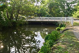 Church Road bridge over the Delaware and Raritan Canal
 -
 Former Belvidere-Delaware Railroad station


See also[edit]
- Howell Living History Farm
- Central Delaware Valley AVA
- Washington Crossing Historic Park, across in the river in Pennsylvania
References[edit]
- ^ a b "2023 U.S. Gazetteer Files: New Jersey". United States Census Bureau. Retrieved July 8, 2024.
- ^ U.S. Geological Survey Geographic Names Information System: Titusville, Geographic Names Information System. Accessed July 8, 2024.
- ^ a b "P1. Race – Titusville CDP, New Jersey: 2020 DEC Redistricting Data (PL 94-171)". U.S. Census Bureau. Retrieved July 8, 2024.
- ^ Geographic Codes Lookup for New Jersey, Missouri Census Data Center. Accessed April 1, 2022.
- ^ "Titusville". Geographic Names Information System. United States Geological Survey, United States Department of the Interior. Retrieved September 29, 2012.
- ^ State of New Jersey Census Designated Places - BVP20 - Data as of January 1, 2020, United States Census Bureau. Accessed December 1, 2022.
- ^ Keyes, Charles Rollin; Prosser, Charles Smith; Eldridge, George Homans; Gannett, Henry (1895). "A Bibliography of North American Paleontology, 1888-1892".
- ^ Locality Search, State of New Jersey. Accessed January 7, 2015.
- ^ "National Register Information System – (#83001604)". National Register of Historic Places. National Park Service. November 2, 2013.
- ^ David Gibson (November 1980). "National Register of Historic Places Inventory/Nomination: Titusville Historic District". National Park Service. Retrieved February 27, 2020. With accompanying 36 photos from 1982
- ^ Washington Crossing State Park, New Jersey Department of Environmental Protection State Park Service. Accessed December 7, 2021.
- ^ Scannell's New Jersey's First Citizens and State Guide, p. 518. J. J. Scannell, 1919. Accessed December 7, 2021. "William Hartwell Blackwell - Titusville - Fruitgrower and Assemblyman. Born at Washington's Crossing, N. J., on July 22, 1882; son of Charles E. and Sarah E. (Hartwell) Blackwell."
- ^ Robyn Jones Archived 2017-11-09 at the Wayback Machine, Franklin & Marshall College. Accessed November 8, 2017. "Hometown: Titusville, NJ; High School: Pennington"
External links[edit]

| International | |
|---|---|
| National | |
- Hopewell Township, Mercer County, New Jersey
- Census-designated places in Mercer County, New Jersey
- Census-designated places in New Jersey
- Unincorporated communities in Mercer County, New Jersey
- Unincorporated communities in New Jersey
- National Register of Historic Places in Mercer County, New Jersey
- Historic districts on the National Register of Historic Places in New Jersey
- New Jersey populated places on the Delaware River